 VN
VN
 EN
EN
25/06/2026, 10:40
Culture- travel
Viet Nam exploits geomorphological resources for geo-ecological tourism
Geomorphological resources are a concept commonly used in the field of geography-geology research and are currently recognised as one of the important resources for tourism development.
According to Associate Professor, Dr. Dang Van Bao, Chairman of the Viet Nam Quaternary-Geomorphology Association, the Earth’s surface topography has been used by humans in development activities for many different purposes, including sightseeing activities (tourism).
However, it was not until the end of the 20th century that topography was considered a natural resource and its features were named as geomorphological resources. Geomorphological resources include unique natural landforms such as mountains, caves, waterfalls, coastlines, etc., that have landscape, tourism, education,and research values.
Some famous geomorphological resources in Viet Nam such as Ha Long Bay (Quang Ninh) and Cat Ba Archipelago (Hai Phong) are world natural heritages recognised by UNESCO, with thousands of limestone islands with unique shapes, forming a rare marine complex, which has been and is being effectively exploited. This terrain is exemplary for the long-term geological-geomorphological evolution process and has outstanding global value.
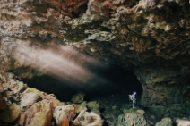
Phong Nha-Ke Bang (Quang Tri) is a unique area with a massive limestone cave system, including Son Doong —the largest natural cave in the world, clearly demonstrating the tectonic, weathering and depositional processes over hundreds of millions of years.
Dong Van Stone Plateau (Tuyen Quang) is the first global geopark in Viet Nam with majestic limestone mountains, deep canyons, and paleontological fossil remains.
Mui Ne-Bau Trang (Lam Dong) is famous for its red sand dunes and white sand dunes, which are rare types of flying sand terrain. The landscape here changes with the wind, creating a unique beauty, and is an attractive destination for both tourists and researchers on desertification.
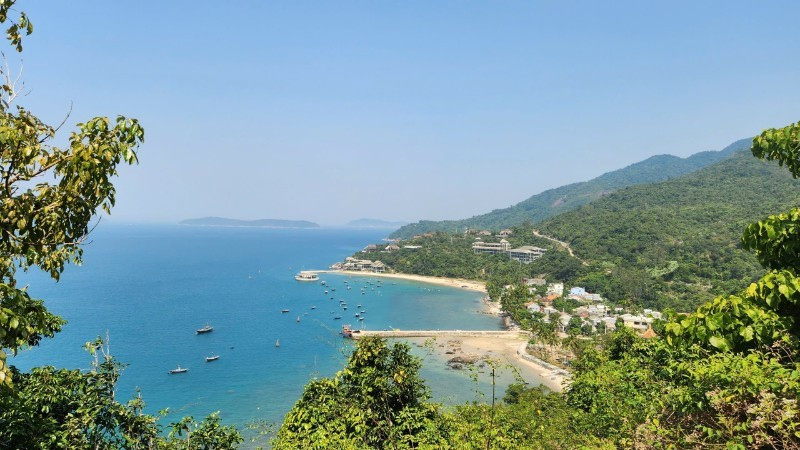
Many areas with unique geomorphological values are being studied, such as the Da Nang-Quang Ngai coastal zone; 46 geomorphological units have recently been identified in this area, including continental terrain, islands, and coastal seabeds, combined into 33 geomorphological resource clusters with rich characteristics of origin such as volcanoes, dissolved limestone terrain creating caves, sinkholes, and valleys.
Typical geomorphological resource clusters here, such as Son Tra Peninsula, Ly Son Island clusters, Cu Lao Cham, Ngu Hanh Son, etc., are not only outstanding in terms of landscape but also act as “outdoor museums” for research on geology, geomorphology, biology, and indigenous history and culture.
Most of the world’s natural heritages and UNESCO global geoparks in the world and Viet Nam are associated with geomorphological resources, but this concept is mainly used by scientists, while awareness in the community is still limited.
Many areas with unique topographic landscapes are forgotten or exploited unsustainably, leading to degradation, even irreversible loss. One of the approaches to catch up with the trend of sustainable development is geo-ecotourism — a new concept that has appeared in the world and has recently been mentioned in Viet Nam.
According to PhD student Pham Thi Phuong Nga, Faculty of Geography at the University of Natural Sciences, Viet Nam National University, Ha Noi, geo-ecotourism is a combination of geotourism and ecotourism, not only helping visitors enjoy the landscape, but also enhancing their understanding of the Earth’s processes in the past and present, the process of forming unique natural landscapes, and so on. At the same time, it encourages people to pay attention to environmental protection education, geoheritage conservation, and ecosystems linked to community livelihoods.
Associate Professor, Dr. Dang Kinh Bac, Faculty of Geography at the University of Natural Sciences, Viet Nam National University, Ha Noi, recommends: “To develop geo-ecological tourism effectively and sustainably, management and investment work needs to put conservation issues before exploitation. Do not let the landscape be destroyed before people and tourists have time to realise its value, which will affect the tourism industry, and in the long term will cause natural disasters and environmental damage.”
Based on diverse and rich geomorphological resources spread across regions, it is evident that Viet Nam has great potential to develop specific tourism products.
According to scientists, what needs to be done is to divide into clusters of tourist destinations associated with geomorphological resources, identify regional tourism centres, and connect themed geomorphological experience routes.
At the same time, deploy solutions such as: building a geomorphological resource assessment system in the direction of scientification, unifying national standards according to criteria groups on science-education, aesthetics, culture-history, environment, and economy to serve the development of geo-ecological tourism; promoting communication and education of tourists according to the model of attracting from the landscape; providing background information and promoting conservation awareness; applying digital technology, for example StoryMaps, to enhance experiences and scientific understanding in a vivid and intuitive manner.
Author: NDO
RECOMMENDED TOPICS