 VN
VN
 EN
EN
12/07/2026, 02:38
Investment
Red River lands offer new opportunities for Hanoi to drive urban expansion
If unlocked in the right way, this land could become a new symbol of Hanoi, one that grows not only outward but also deeper into cultural, ecological and community values.
Eighty years ago in Hanoi, President Ho Chi Minh delivered the Declaration of Independence, giving birth to the modern Vietnamese state and marking a new era for the country.
Today, the capital and the whole country are entering a new era of development, carrying forward values shaped over a thousand years.

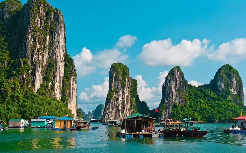
The Red River's alluvial islet. Photo: Pham Hung/The Hanoi Times
In this flow of history, the revival of the Red River banks should be seen as a breakthrough, a symbolic act, a way to honor the past, preserve nature’s rhythm, and hand down a worthy legacy to future generations.
The Red River has long carried layers of history, culture, farming and daily life. For centuries, villages along the banks formed centuries ago, their customs and lifestyles tied to the river’s cycles.
For many Hanoians, the mid-river islet and riverbanks hold many memories that connect urban life with nature.
This land keeps folklore and legends that embody the Vietnamese spirit of resilience against harsh conditions. These riverbanks have stood witness to the capital’s thousand-year history, from the era of the Hung Kings, through King Ly Thai To’s move from Hoa Lu to establish Thang Long, to the present era of modernization.
Like the Huong River in Hue, the Han River in Danang, the Cam River in Haiphong, and the Saigon River in Ho Chi Minh City, the Red River represents Hanoi. But unlike those rivers, which have been fully integrated into urban planning, the Red River section running through the capital still struggles to find direction.
Although the alluvial islet grows year by year, infrastructure on this land faces conflicts and legal hurdles. Hanoi faces the challenge of balancing flood control with urban growth, while traditional villages slowly fade.
Over the decades, land along the riverbanks has been used spontaneously for farming, makeshift housing, warehouses, or simply left idle. Urban development here has lacked a coherent master plan, often driven by short-term projects without long-term vision.
Hanoi has tried several projects to reshape the riverbanks such as a pilot one-kilometer urban development in Nhat Tan–Tu Lien, and a master plan for the Red River section through the city.
In February 2025, the city hosted a design competition for a multifunctional cultural park on the river’s islets and banks, signaling renewed ambition.
Yet these attempts either failed to convince the public or remained on paper.
In today’s context, institutional reforms are opening new opportunities and energy for bold changes in Red River urban planning.
Two-tier local government model drives Red River urban development
The 80th anniversary of the August Revolution and National Day on September 2 marks a turning point in the capital’s development.

Chrysanthemum garden on the alluvial land beneath Long Bien Bridge. Photo: Cong Hung/The Hanoi Times
The revised Capital Law, effective July 1, 2025, provides a special legal framework for Hanoi in planning, investment, management, and growth.
The Capital Master Plan for 2021–2030, with a vision to 2050, together with adjustments to the General Plan for 2045 and a vision to 2065, outlines a long-term future for the city.
A major step is the adoption of a two-tier local government model, starting July 1, 2025.
This reform strengthens decentralized governance, paving the way for modern and effective urban management.
Under this model, wards and communes along the Red River such as Thuong Cat, Dong Ngac, Phu Thuong, Hong Ha, Linh Nam, Bo De, Long Bien, Me Linh, Dong Anh, Bat Trang, and Thanh Tri will gain more autonomy in planning, investment, management, and preservation, balancing community needs with the capital’s strategic development.
For the riverbanks to become a model urban space, Hanoi must play its role as both a strategist and an inspiration for change.
The city needs a dedicated plan for the area, prioritizing ecological preservation, urban farming, soft infrastructure, community tourism, and housing adapted to natural conditions instead of relying on simple concrete expansion.
To unlock the potential of the Red River banks, Hanoi should restore and enhance the river’s role as the city’s main cultural and ecological axis, bridging past and present.
Development should follow the model of a “riverfront city” with public spaces, green transport, and cultural-tourism activities in Hong Ha Ward, while preserving and promoting craft villages such as Bat Trang, Tu Lien, and Nhat Tan, alongside traditional farmland.
Modern infrastructure should also be integrated to improve the quality of life for local residents.
At the same time, flood control, water environment improvement and eco-landscaping must be combined with building a creative economic corridor along both banks, attracting major projects at Tam Xa, Long Bien, and beyond, connected to Hanoi’s metropolitan network.
The planning model should be structured around a “main axis – functional zones – ecological corridor”.
The main axis would be a continuous public space along the river, linking docks, squares, parks, and open museums.
The functional zones would include new urban areas, cultural-commercial-tourism clusters, and upgraded traditional settlements.
The ecological corridor would form a green belt of wetlands, community gardens, and protective tree lines, preserving nature while softening urban space.
Yet every plan can only be sustainable if the community is at its center. Longtime residents, who have lived in harmony with the river, must be heard, empowered, and involved.
They are the storytellers and keepers of memory, carrying local identity into the riverbanks’ future.
Those residents need land, livelihoods, social support and training so they are not get displaced but instead become active participants in the transformation.
A sustainable city is one that lifts and includes vulnerable groups in development, not just a political requirement, but also a moral principle.
The Red River banks are where memory meets the future. A once-forgotten land quietly is waiting to be awakened, a living testimony to the resilience and creativity of a city more than a thousand years old.
If developed wisely, this land could become a new symbol of Hanoi – a capital that grows not only outward but also deeper in culture, ecology, and community.
Urban growth is far from mere building of roads and houses. It is about renewing old values, reviving forgotten lands, and writing the next chapter of the city with the language of inclusiveness, sustainability and aspiration.
If shaped in the right direction, the Red River banks could be the place where a deeper, fairer and more livable Hanoi begins.
Author: Hanoitimes
RECOMMENDED TOPICS